| Stack layer | Primary job | Typical output |
|---|---|---|
| Sensor fusion | Combine raw multi-sensor data into one consistent signal | Synchronized point clouds, images, and motion estimates |
| SLAM | Localize the robot while building a map | Robot pose plus an occupancy or feature map |
| Semantic mapping | Attach meaning and object identity to the map | Labeled objects, scene graphs, navigable regions |
Perception Is a Stack, Not a Single System
When people talk about a robot “seeing” its environment, they usually collapse a multi-stage software pipeline into a single mental image. In practice, modern robot perception is built in layers, each with a distinct job, distinct failure modes, and distinct compute requirements. Understanding the full stack — not just the trendiest layer — is what separates a robot that merely avoids obstacles from one that can operate reliably in a changing, human-populated environment.
This piece walks through the three foundational layers of a modern robot perception stack: raw sensor fusion at the bottom, Simultaneous Localization and Mapping (SLAM) in the middle, and semantic mapping and scene understanding at the top. We treat SLAM as one stage within this broader architecture rather than as the whole story; readers who want a deep, algorithm-level treatment of SLAM specifically should see our companion piece, The Evolution of SLAM Technology for Urban Robots, which covers that ground in far more depth than we will here.
Layer One: Raw Sensor Fusion
Every perception stack starts with raw data, and raw data from a single sensor is rarely good enough on its own. LiDAR provides precise geometric structure but almost no semantic detail. Cameras provide rich color and texture but no direct depth. Inertial measurement units (IMUs) provide fast, high-frequency motion estimates but drift over time without correction. Sensor fusion is the layer that combines these complementary signals into a single, more reliable representation than any one sensor could produce alone.
Fusion at this level typically happens in one of two ways. Early (low-level) fusion combines raw or lightly processed data — for example, projecting LiDAR points directly onto camera image planes before running detection — preserving more information but requiring precise time synchronization and extrinsic calibration between sensors. Late (high-level) fusion runs each sensor’s processing pipeline independently and merges the resulting object lists or pose estimates afterward, which is computationally simpler and easier to debug but can lose subtle cross-sensor cues.
| Fusion approach | Advantage | Trade-off |
|---|---|---|
| Early fusion | Preserves fine-grained cross-sensor detail | Requires tight synchronization and calibration |
| Late fusion | Simpler, modular, easier to debug | Can miss subtle correlations between sensors |
| Hybrid fusion | Balances precision and robustness | More complex architecture to maintain |
The output of this layer is not a map or a location — it is a cleaned, synchronized, and spatially aligned stream of sensor data ready for the next stage. Getting this layer wrong (through poor time synchronization, drifting calibration, or naive merging of noisy signals) propagates errors into every layer built on top of it, which is why experienced teams invest disproportionate effort here even though it produces the least visible or demo-friendly output.
Layer Two: SLAM, the Localization and Mapping Core
Simultaneous Localization and Mapping (SLAM) takes the fused sensor stream and answers two intertwined questions at once: where is the robot, and what does the surrounding space look like? A generalized SLAM pipeline involves feature extraction from sensor data, data association between observations and previously seen landmarks, motion estimation (odometry), map initialization, loop closure detection when the robot revisits a known area, and ongoing map optimization to correct accumulated drift.
SLAM implementations vary widely depending on the primary sensor driving them. LiDAR-based SLAM tends to produce highly accurate geometric maps and is a common choice for structured indoor environments. Visual SLAM, built primarily on camera input, is lighter weight and cheaper to deploy but more sensitive to lighting changes and low-texture scenes. Visual-inertial SLAM combines a camera with an IMU to improve robustness during fast motion or brief periods of visual occlusion. Multimodal SLAM approaches that fuse LiDAR, vision, and IMU data together have become increasingly common as compute budgets have grown, because each modality compensates for the others’ weaknesses: LiDAR supplies precise structure, vision supplies rich semantic cues, and IMU data compensates for short-term motion uncertainty between sensor readings.
It is worth being explicit about scope here: SLAM algorithms themselves — their mathematical formulations, loop closure techniques, and optimization backends — are a deep enough topic to warrant their own dedicated treatment, which is exactly what our SLAM-focused guide provides. In this piece, SLAM is one stage in a larger pipeline: it hands off a robot pose and a geometric map to the next layer, semantic mapping, rather than being the final output a robot’s software stack cares about.
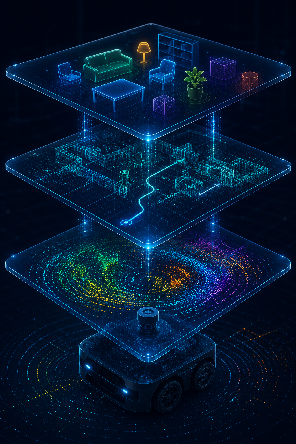
The Three-Layer Perception Pipeline
Raw sensor streams from LiDAR, camera, and IMU are time-synchronized and fused into a unified spatial signal. That signal feeds a SLAM module, which outputs a robot pose and a geometric map through feature extraction, data association, and loop closure. The geometric map is then passed to a semantic mapping layer, which classifies objects and regions, producing a scene-level representation usable by planning and task-execution software.
Layer Three: Semantic Mapping and Scene Understanding
A purely geometric map tells a robot that a surface exists at a given location; it does not tell the robot whether that surface is a wall, a door, a person, or a forklift. Semantic mapping is the layer that closes this gap, attaching object-level labels and scene-level meaning on top of the geometric structure that SLAM produces. This is where deep learning-based object detection, instance segmentation, and increasingly, vision-language models, do most of their work.
Modern semantic mapping systems produce increasingly rich representations: not just 2D occupancy grids or 3D point clouds, but topological graphs describing how rooms or regions connect, semantic meshes that label surfaces by object class, and hierarchical situational maps that combine geometry, object identity, and relational context (this shelf is inside that aisle, which is inside that warehouse zone). The field has been moving from purely geometric, classical SLAM-centric architectures toward what researchers describe as AI-native perception architectures, where the semantic-conceptual layer is treated as a first-class part of the pipeline rather than a downstream add-on bolted onto a geometric map.
| Map representation | What it captures | Common use case |
|---|---|---|
| Occupancy grid | Binary or probabilistic free/occupied space | Basic obstacle avoidance |
| 3D point cloud | Raw geometric structure | Precise navigation, manipulation planning |
| Topological graph | Connectivity between named regions | Long-range route planning across large facilities |
| Semantic mesh / scene graph | Labeled objects and their relationships | Task-level reasoning (“find the nearest exit”) |
How the Layers Fit Together in Production Systems
In a production robot, these three layers rarely run as fully separate, sequential stages; they operate more like a pipeline with feedback loops. Semantic information can feed back down to improve SLAM’s data association (recognizing that a moving object detected semantically as “a person” should be excluded from the static map), and sensor fusion parameters are sometimes adjusted dynamically based on what the semantic layer identifies about the current scene, such as switching to a more conservative fusion strategy in a crowded, dynamic space versus an empty static one.
System architectures have also evolved beyond a single onboard compute pipeline. Some deployments now split perception processing across robot, edge, and cloud tiers, with latency-critical fusion and SLAM running onboard while heavier semantic reasoning or multi-robot map merging runs on nearby edge infrastructure or in the cloud. Fully distributed multi-robot perception systems take this further, allowing a fleet of robots to share and merge semantic maps of a shared environment, which is valuable for warehouse and logistics operations where multiple robots cover overlapping territory.
Common mistake
Teams frequently over-invest in the semantic mapping layer — adding ever more sophisticated object detection and scene understanding models — while treating the underlying sensor fusion and SLAM layers as a solved, “good enough” foundation. When the fusion layer has poor time synchronization or the SLAM layer accumulates drift in a large facility, no amount of sophistication in the semantic layer can compensate, because it is reasoning about a spatially incorrect map.
What worked
Programs that scaled successfully treated the three layers as independently testable and monitorable subsystems, with dedicated metrics for each: calibration drift and synchronization jitter for the fusion layer, localization error and loop closure success rate for SLAM, and object detection precision/recall for the semantic layer. Isolating failures to a specific layer, rather than debugging “the perception system” as one monolithic block, cut diagnosis time substantially during field trials.
Compute, Latency, and the Cost of Getting the Stack Wrong
Each layer of the perception stack has a different appetite for compute and a different tolerance for latency, and mismatched expectations between the two are a common source of production problems. Sensor fusion and the front end of SLAM are typically the most latency-sensitive parts of the pipeline, because a robot moving at even modest speed needs its pose estimate updated many times per second to avoid drifting into obstacles between updates. Delays of even a few tens of milliseconds in this part of the stack can measurably degrade navigation quality, which is why these stages are usually kept onboard on dedicated compute rather than routed over a network connection.
Semantic mapping has more flexibility. Object detection and scene understanding models can often tolerate somewhat higher latency, since the identity of an object rarely changes as quickly as the robot’s own position does. This is exactly why semantic processing is a common candidate for offloading to edge servers or cloud infrastructure, particularly for tasks like periodic full-facility re-mapping, cross-robot map merging, or applying larger, more capable models than would fit on constrained onboard hardware.
Cost follows a similar pattern to latency sensitivity. Running dense LiDAR-based SLAM and high-resolution semantic segmentation simultaneously on every frame, on every robot in a fleet, can quickly exceed a reasonable power and compute budget, especially for battery-powered mobile platforms. Many production teams handle this by running full semantic inference only on keyframes or at a reduced rate relative to the fusion and SLAM loop, then propagating semantic labels forward between keyframes using cheaper tracking methods. This kind of rate decoupling between layers is one of the more effective, if underappreciated, levers for keeping a perception stack both accurate and affordable to run at fleet scale.
Getting this balance wrong shows up in predictable ways: robots that hesitate or jitter near obstacles usually have a fusion or SLAM bottleneck, while robots that navigate smoothly but consistently misidentify objects or fail to update stale semantic labels usually have an underprovisioned or poorly rate-tuned semantic layer. Diagnosing which layer is actually responsible for a given field complaint is far easier when the layers have been instrumented separately from the start, rather than treated as a single black box.
Frequently Overlooked Considerations
- Time synchronizationEvery layer above sensor fusion inherits any timestamp misalignment from below; a few milliseconds of drift between sensors can cascade into meters of mapping error in fast motion.
- Dynamic object filteringSLAM assumes a largely static world; without semantic input to flag moving objects like people or forklifts, they can be incorrectly baked into the static map.
- Loop closure false positivesVisually similar but distinct locations (identical warehouse aisles, for example) can trigger incorrect loop closures that corrupt the map unless semantic context disambiguates them.
- Compute tiering decisionsDeciding what runs onboard versus at the edge or in the cloud affects latency, bandwidth cost, and resilience to connectivity loss, and is often decided too late in the design process.
- Map stalenessSemantic maps of dynamic environments (retail floors, warehouses with shifting inventory) degrade in usefulness over time without a re-mapping or continuous-update strategy.
- Cross-robot map mergingFleets sharing a semantic map need consistent coordinate frames and conflict-resolution logic when two robots observe the same area differently at different times.
Glossary
- Sensor fusion
- The process of combining raw or processed data from multiple sensor types, such as LiDAR, camera, and IMU, into a single, more reliable representation of the environment.
- SLAM
- Simultaneous Localization and Mapping, the process by which a robot estimates its own position while concurrently building a map of an unknown environment.
- Loop closure
- The process of recognizing that a robot has returned to a previously visited location, used to correct accumulated drift in a SLAM map.
- Semantic mapping
- The layer of a perception stack that attaches object-level labels and scene-level meaning to an otherwise purely geometric map.
- Scene graph
- A structured representation that captures objects in an environment along with the relationships between them, such as which objects are inside or near others.
Key Takeaways
- A robot perception stack is a layered pipeline: sensor fusion at the base, SLAM in the middle, and semantic mapping on top.
- Sensor fusion combines complementary sensor data into one aligned signal; poor synchronization here corrupts every layer built above it.
- SLAM answers “where am I and what does the space look like,” producing a pose and a geometric map, but is only one stage in the broader stack.
- Semantic mapping adds object-level meaning on top of SLAM’s geometry, enabling task-level reasoning rather than just obstacle avoidance.
- Production systems increasingly use feedback loops between layers, such as semantic detection informing which objects SLAM should treat as dynamic.
- Perception architectures are shifting from single onboard pipelines toward robot-edge-cloud tiers and distributed multi-robot map sharing.
- Debugging perception is most effective when each layer is tested and monitored independently, rather than treated as one monolithic system.
FAQs
What is a robot perception stack?
A robot perception stack is the layered software architecture that turns raw sensor data into an understanding of the environment a robot can act on. It typically includes raw sensor fusion at the base, SLAM for localization and geometric mapping in the middle, and semantic mapping for object-level understanding at the top.
How is sensor fusion different from SLAM?
Sensor fusion combines raw data from multiple sensors, such as LiDAR, camera, and IMU, into a single aligned signal. SLAM takes that fused signal and uses it to simultaneously estimate the robot’s position and build a map of the environment, which is a distinct and later stage in the pipeline.
Why is semantic mapping considered a separate layer from SLAM?
SLAM produces a geometric representation of where surfaces and obstacles are located, but it does not inherently know what those surfaces are. Semantic mapping adds object identity and scene-level meaning on top of SLAM’s geometric output, enabling reasoning about objects and their relationships rather than just spatial structure.
What are the main types of SLAM used in robot perception stacks?
Common variants include LiDAR-based SLAM for precise geometric mapping, visual SLAM using camera input for lighter-weight deployments, visual-inertial SLAM combining cameras with IMU data for robustness during fast motion, and multimodal SLAM that fuses LiDAR, vision, and IMU together for improved accuracy and resilience.
What happens if sensor fusion has poor time synchronization?
Poor time synchronization between sensors causes misaligned data to propagate into every layer built on top of it. This can cause SLAM to miscalculate the robot’s pose and introduce mapping errors that are difficult to correct further up the stack, even with sophisticated semantic mapping algorithms.
How do modern perception stacks handle moving objects like people?
SLAM generally assumes a largely static environment, so without help it can incorrectly incorporate moving objects into the static map. Semantic mapping layers help by identifying dynamic objects, such as people or forklifts, so they can be filtered out of the map that SLAM maintains.
Why are some perception stacks moving computation to the edge or cloud?
Latency-critical tasks like sensor fusion and SLAM often need to run onboard for real-time responsiveness, while heavier semantic reasoning or multi-robot map merging can be offloaded to nearby edge infrastructure or the cloud to save onboard compute and power, especially in fleet deployments.
Where can I learn more about SLAM algorithms specifically?
For an in-depth, algorithm-focused treatment of SLAM techniques for urban robots, including loop closure methods and mapping approaches, see our dedicated guide, The Evolution of SLAM Technology for Urban Robots, which goes deeper into SLAM specifically than this broader perception stack overview.
References
- PatSnap Eureka, “Robot SLAM Technology Landscape 2026”
- RTKdata, “Sensor Fusion Robotics: Localization Stack 2026”
- arXiv, “Multimodal Fusion and Vision-Language Models: A Survey for Robot Vision”
- MDPI, “Research on Indoor 3D Semantic Mapping Based on ORB-SLAM2 and Multi-Object Tracking”
- NCBI/PMC, “A Review on Visual-SLAM: Advancements from Geometric Modelling to Learning-Based Semantic Scene Understanding Using Multi-Modal Sensor Fusion”
Teams choosing the hardware that feeds this entire stack should also read our breakdown of LiDAR, radar, and camera trade-offs for autonomy. Middleware questions around running these perception nodes in production are covered in ROS 2 in production environments, and fleets pushing perception model updates in the field should review over-the-air updates without breaking safety cases. Perception stacks that inform safety-critical decisions should also be built against the framework in functional safety standards for robots, and teams building digital simulation environments for testing perception may find digital twins for robotics useful.