The integration of artificial intelligence with unmanned aerial vehicles (UAVs) has fundamentally shifted how food is grown. AI drones for precision agriculture are no longer futuristic concepts reserved for research stations; they are active, essential tools deployed on farms ranging from small family vineyards to massive industrial grain operations. By combining the mobility of drones with the analytical power of machine learning, farmers can now see the invisible—detecting stress, disease, and nutrient deficiencies long before they are visible to the human eye.
This guide provides a comprehensive look at the ecosystem of AI-guided agricultural drones. We will explore the specific technologies that make them “intelligent,” the practical workflows for implementing them, the return on investment (ROI) they offer, and the regulatory realities operators face today.
Key Takeaways
- Beyond Photography: AI drones do not just take pictures; they analyze data in real-time or post-flight to identify specific issues like nitrogen deficiency, irrigation leaks, or pest infestations.
- Targeted Action: The primary value is “precision”—applying water, fertilizer, or pesticide only where needed, rather than blanket-spraying entire fields.
- Sensor Diversity: Success depends on the payload. RGB cameras, multispectral sensors, thermal imagers, and LiDAR serve different diagnostic purposes.
- Data is the Product: The drone is merely the delivery mechanism for the data. The real value lies in the software platforms that interpret flight data into actionable prescription maps.
- Regulatory Compliance: As of January 2026, operating these drones requires adherence to strict aviation guidelines (such as Part 107 in the US or EASA Specific Category in Europe), especially regarding Beyond Visual Line of Sight (BVLOS) operations.
Who This Is For (And Who It Isn’t)
This guide is written for agronomists, farm managers, agricultural consultants, and technology integrators looking to understand or deploy drone solutions. It assumes a professional interest in improving farm efficiency.
This guide is not a basic hobbyist manual for flying consumer drones, nor is it a highly theoretical academic paper on aerodynamics. It focuses on the applied intersection of agronomy and autonomous technology.
What Are AI-Guided Drones?
In the context of agriculture, an “AI-guided drone” refers to a UAV system that utilizes artificial intelligence—specifically computer vision and machine learning algorithms—to perform tasks autonomously or to analyze data with human-level (or superior) perception.
While a standard drone is a remote-controlled camera, an AI-guided drone serves as an intelligent edge device. It can function in two primary modes:
- Real-Time Edge Computing: The drone processes data onboard. For example, a drone equipped with a specialized GPU can identify a specific weed species while flying and trigger a spot-spray nozzle instantly. This eliminates the need to land, upload data, and wait for processing.
- Post-Process Analytics: The drone flies a pre-programmed path to collect massive datasets. Once uploaded to the cloud, AI algorithms stitch thousands of images together and analyze the resulting orthomosaics to count plant stands, estimate yields, or categorize crop health.
The Core Tech Stack
To understand the capability, one must look beyond the rotors. The “intelligence” relies on three components:
- The Platform: The physical drone (usually a quadcopter or fixed-wing) capable of carrying payloads and flying autonomous grid patterns.
- The Sensor Payload: The eyes of the system. This includes multispectral cameras (capturing Near-Infrared light), thermal sensors, and high-resolution RGB cameras.
- The AI Model: The software trained on thousands of images of crops to recognize patterns. For instance, a model might be trained specifically to distinguish between a healthy soybean leaf and one infected with Frogeye Leaf Spot.
How Computer Vision and Sensors Power Smart Farming
The effectiveness of AI drones for precision agriculture relies entirely on the quality of data they capture. Different sensors reveal different truths about the crop.
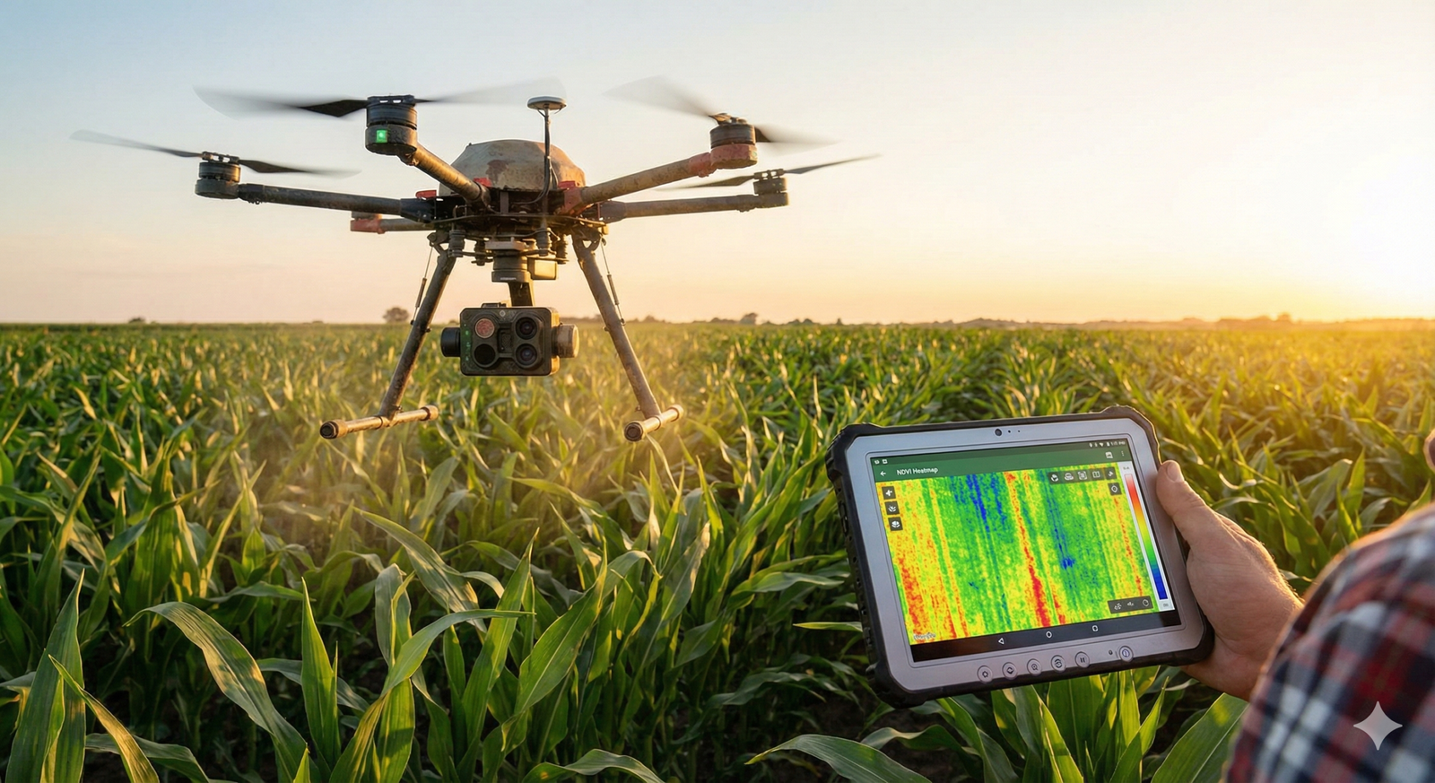
Multispectral Imaging and NDVI
The most common application of agricultural drones is collecting multispectral data to calculate vegetation indices, most notably the Normalized Difference Vegetation Index (NDVI).
Healthy plants reflect a significant amount of near-infrared (NIR) light and absorb visible red light for photosynthesis. Stressed plants do the opposite. Multispectral sensors capture these specific wavelengths.
- How AI Helps: Basic NDVI provides a simple color map (green is good, red is bad). AI advances this by correlating specific spectral signatures with specific causes. Instead of just seeing “stress,” advanced algorithms can differentiate between drought stress (thermal signature) and nitrogen deficiency (spectral signature).
Thermal Imagery for Water Management
Thermal sensors measure the temperature of the plant canopy. Transpiration cools plants; therefore, a plant that is running hot is often closing its stomata due to water stress.
- Practical Application: AI models analyze thermal maps to identify clogged irrigation nozzles or leaks in drip lines. In vineyards, this data regulates “regulated deficit irrigation” strategies to optimize grape quality.
RGB and Morphology Analysis
High-resolution standard cameras are used for “stand counts” (counting the number of emerged plants) and weed detection.
- Computer Vision in Action: This is where Deep Learning shines. Convolutional Neural Networks (CNNs) analyze the shape (morphology) of leaves. The AI counts individual corn stalks in a field of thousands to calculate germination rates with 98%+ accuracy. Similarly, it identifies weeds between rows to generate “spot spray” maps for tractors or spray drones.
Key Applications in Modern Farming
The utility of AI drones spans the entire growing season, from pre-planting soil analysis to harvest estimation.
1. Soil and Field Analysis
Before planting, drones generate 3D maps of the terrain using photogrammetry or LiDAR. AI models analyze slope and elevation to recommend drainage solutions and prevent soil erosion. This data informs variable rate seeding (VRS) plans, ensuring seeds are planted at densities appropriate for the soil’s topography and potential water retention.
2. Crop Health Monitoring (Scouting)
Traditional crop scouting involves an agronomist walking a ‘W’ pattern through a field, observing perhaps 1% of the crop.
- The AI Advantage: Drones cover 100% of the field. Anomaly detection algorithms flag specific coordinates where the spectral signature deviates from the norm. The agronomist then walks directly to those problem spots—a method known as “ground-truthing.” This optimizes the human expert’s time.
3. Precision Spraying and Weeding
This is arguably the highest-value application. Instead of broadcasting herbicides over an entire field, “See & Spray” drones use onboard AI to identify weeds and spray them individually.
- Resource Savings: Studies have shown this approach can reduce herbicide usage by up to 90%, significantly lowering input costs and environmental runoff.
- Spot Spraying: For fungicides, drones can target specific clusters of infection (hotspots) to prevent spread, rather than treating the whole crop prophylactically.
4. Yield Estimation
Forecasting yield is critical for logistics (how many trucks to book) and marketing (when to sell futures).
- How it works: In fruit orchards (like apples or citrus), computer vision models count the fruit on trees from aerial imagery. In grain crops, AI estimates biomass volume and ear density to predict tonnage per acre with high precision, often weeks before harvest.
5. Livestock Management
While primarily associated with crops, AI drones equipped with thermal cameras are used to locate livestock in vast pastures, identify sick animals (via elevated body temperature), and even monitor grazing patterns to prevent overgrazing in specific zones.
The Workflow: From Flight Planning to Actionable Insights
Implementing AI drones for precision agriculture requires a disciplined workflow. It is not as simple as flying the drone and looking at the screen.
Phase 1: Mission Planning
Operators use flight planning software (such as DJI Terra, Pix4Dcapture, or DroneDeploy) to define the field boundaries.
- Parameters: The user sets the overlap (usually 70-80% front and side overlap) and altitude. Lower altitude yields higher resolution (GSD – Ground Sampling Distance) but takes longer.
- Automation: The drone takes off, flies the grid autonomously, and lands without manual stick input.
Phase 2: Data Acquisition
During the flight, the drone captures hundreds or thousands of geotagged images.
- Real-World Constraint: Lighting matters. Flights are best conducted around solar noon to minimize shadows that can confuse AI models. Cloud cover should be consistent (either fully clear or fully overcast) to avoid “rolling shadows” that distort spectral data.
Phase 3: Processing and Stitching
The data is transferred to a processing engine.
- Orthomosaic Generation: Software stitches the images into a single, high-fidelity map of the field.
- Geometric Correction: The software corrects for lens distortion and perspective tilt.
Phase 4: AI Analysis and Prescription
This is the intelligence layer. The processed map is run through agronomic algorithms.
- Zoning: The AI divides the field into management zones based on health.
- Prescription Maps: The software generates a “shapefile” (.SHP) compatible with farm machinery (e.g., John Deere or Case IH terminals). This file tells the tractor exactly how much fertilizer to apply in each zone.
Benefits of Integrating AI Drones
The adoption of agricultural UAVs is driven by tangible economic and agronomic benefits.
Increased Efficiency and Speed
A drone can scout 100 acres in 20-30 minutes, a task that would take a human scout all day to cover less thoroughly. This speed allows for more frequent monitoring, catching problems days before they become critical.
Cost Reduction (Inputs)
By facilitating Variable Rate Technology (VRT), farmers stop wasting expensive inputs.
- Fertilizer: Nitrogen is applied only where the crop is deficient.
- Chemicals: Herbicides are applied only to weeds.
- Water: Irrigation is targeted to dry zones.
- Example: If a farmer saves $15 per acre on chemicals across a 2,000-acre farm, the savings ($30,000) can pay for the drone system in a single season.
Environmental Stewardship
Precision agriculture reduces the chemical load on the soil and prevents fertilizer runoff into local waterways (eutrophication). This helps farms meet increasingly strict environmental regulations and sustainability certification standards.
Data-Driven Decisions
Farming has traditionally relied on intuition and historical memory. AI drones digitize the field, creating a permanent record of crop performance. This creates a feedback loop: farmers can look back at last year’s data to see exactly which seed varieties performed best in which soil zones.
Challenges and Limitations
Despite the hype, there are significant friction points in deploying AI drones for precision agriculture.
Battery Life and Flight Time
Most electric multi-rotor drones have a flight time of 20–30 minutes with a payload. This limits coverage to roughly 80–120 acres per battery. For massive operations (5,000+ acres), this requires stopping constantly to swap batteries, which is logistically difficult. Fixed-wing drones offer longer flight times (60+ minutes) but are harder to launch and land.
Data Volume and Connectivity
A single flight can generate gigabytes of data. Rural internet infrastructure is often poor. Uploading 10GB of high-res imagery to the cloud for processing can take days on a slow connection.
- Workaround: Many operators use powerful local laptops (“edge processing”) to stitch maps in the field, but this requires expensive hardware.
Weather Dependency
Drones cannot fly in high winds (usually >25 mph) or rain. Unfortunately, farmers often need data most urgently after a storm to assess hail or wind damage, exactly when conditions might still be poor.
Complexity of Interpretation
An NDVI map showing “red” (stress) doesn’t tell you why the plant is stressed. Is it bugs? Water? Disease? AI is getting better at diagnosis, but “ground-truthing” by a knowledgeable human is still mandatory. The drone is a triage tool, not a doctor.
Regulatory Landscape and Safety
As of January 2026, the regulatory environment for agricultural drones is maturing but remains a primary constraint.
United States (FAA)
- Part 107: Commercial drone operators must hold an FAA Part 107 Remote Pilot Certificate.
- Weight Restrictions: Agricultural spray drones often weigh more than 55 lbs (25 kg). Operating these requires a specific exemption (under 49 U.S.C. § 44807) from the FAA, which is a complex legal process.
- BVLOS (Beyond Visual Line of Sight): Most standard regulations require the pilot to see the drone at all times. This severely limits the efficiency of mapping large fields. While the FAA has been granting more BVLOS waivers, it is not yet “open season” for fully autonomous, unsupervised flight.
European Union (EASA)
EASA regulations categorize operations into Open, Specific, and Certified. Large spray drones typically fall into the “Specific” category, requiring an operational risk assessment (SORA).
Safety Considerations
Agricultural drones are large, heavy industrial equipment. A spray drone carrying 30 liters of liquid has significant kinetic energy. Safety protocols must include:
- Geofencing to prevent flyaways.
- Return-to-Home (RTH) fail-safes for signal loss.
- Strict exclusion zones around power lines and public roads.
Cost Considerations and ROI Analysis
Adopting this technology involves both CapEx (Capital Expenditure) and OpEx (Operational Expenditure).
Hardware Costs
- Entry-Level Scouting: A prosumer drone with a good RGB camera costs between $2,000 and $4,000.
- Multispectral Setup: A drone equipped with a quality multispectral sensor (like a MicaSense or similar) typically ranges from $8,000 to $15,000.
- Spray Drones: Large autonomous spray drones (e.g., DJI Agras series or XAG) range from $15,000 to $30,000+, not including the generator and batteries needed for continuous operation.
Software and Processing
Most detailed AI analytics platforms operate on a subscription model (SaaS).
- Processing fees: Expect to pay $100–$300 per month or a per-acre fee for cloud processing and storage.
Return on Investment (ROI)
ROI is highest for high-value crops (vineyards, orchards, vegetables) where individual plant health directly correlates to market price.
- Example Calculation: If a drone detects a nitrogen deficiency in corn early enough to correct it via side-dressing, saving 5 bushels per acre across 1,000 acres at $5/bushel, the revenue increase is $25,000. This single intervention covers the cost of the hardware.
Best Practices for Implementation
For farms or service providers looking to start using AI drones, a phased approach is recommended to avoid “tech bloat.”
1. Start with the Problem, Not the Drone
Do not buy a drone looking for a use case. Identify the bottleneck. Is it weed control costs? Is it inaccurate yield forecasts? Choose the sensor payload that solves that specific problem.
2. Master Data Management Early
Before the first flight, decide how you will organize the data. Naming conventions (Year_Field_Crop_Date) are vital. Without organization, you will end up with terabytes of unsearchable images.
3. Integrate with Ground Machinery
The data is useless if it stays on the computer. Ensure your drone software can export files compatible with your tractor’s variable rate controller. The “loop” must be closed—from sky to soil.
4. Respect the Learning Curve
Flying a grid is easy; analyzing the data is hard. Invest in training for agronomic data interpretation, or partner with a service provider who specializes in analytics.
Future Trends: Swarms and Autonomy
The future of AI drones for precision agriculture lies in removing the pilot from the loop entirely.
Drone-in-a-Box (DiaB)
These are autonomous docking stations placed permanently in fields. The drone wakes up on a schedule, conducts a daily scout, lands, charges, and uploads data—all without human intervention. As regulations loosen regarding BVLOS, DiaB systems will become standard infrastructure on large farms, similar to irrigation pivots.
Swarm Technology
Instead of one massive drone, “swarms” of smaller drones will operate cooperatively. If one drone detects a large weed patch, it can signal others to converge and assist in spraying. This redundancy ensures the mission continues even if one unit fails.
Hyper-Local Weather Modeling
Drones will eventually act as mobile weather stations, measuring humidity and temperature at the canopy level across the field to predict micro-climate disease outbreaks with unprecedented accuracy.
Related Topics to Explore
To deepen your understanding of the precision agriculture ecosystem, consider exploring these related concepts:
- Variable Rate Technology (VRT): The machinery side of applying inputs based on drone maps.
- Satellite vs. Drone Imagery: Understanding the trade-offs between daily satellite passes and on-demand drone flights.
- Edge Computing in IoT: How sensors process data locally to reduce bandwidth usage.
- Regenerative Agriculture Tech: How technology validates soil carbon sequestration.
- Automated Ground Vehicles (AGVs): The ground-based robots that complement aerial drones.
Conclusion
AI drones for precision agriculture represent a critical convergence of aviation, agronomy, and artificial intelligence. They offer a practical solution to the modern farmer’s dilemma: how to produce more food with fewer inputs and less environmental impact.
While the technology introduces new complexities—specifically regarding data management and regulation—the trajectory is clear. As battery technology improves and AI models become more robust, these flying sensors will become as ubiquitous on the farm as the tractor itself. The transition from “reactive” farming (fixing problems after they appear) to “proactive” farming (preventing problems based on predictive data) is already underway.
For producers ready to adopt this technology, the next step is clear: Define your primary agronomic pain point, select the appropriate sensor payload, and begin building a data workflow that turns aerial pixels into profitable decisions.
FAQs
1. Do I need a license to fly a drone for agriculture? Yes. In the United States, if you are flying for any commercial purpose (including farming your own land to improve yield/profit), you must hold an FAA Part 107 Remote Pilot Certificate. In the EU and other regions, similar competency certifications are required.
2. Can AI drones completely replace crop scouts? No. AI drones are tools to augment crop scouts, not replace them. They make scouts more efficient by directing them to specific trouble spots (“directed scouting”). A human agronomist is still needed to diagnose the root cause of the stress (e.g., distinguishing between a fungal disease and a nutrient deficiency) if the spectral signature is ambiguous.
3. What is the difference between an RGB and a Multispectral camera? An RGB camera captures visible light (Red, Green, Blue) just like a smartphone. It is good for visual inspections and counting plants. A Multispectral camera captures invisible bands of light (specifically Near-Infrared and Red Edge) which correlate directly to plant chlorophyll activity and stress. You generally need multispectral sensors for true health analysis.
4. How accurate are yield estimates from drones? Accuracy varies by crop and growth stage. For row crops like corn, stand counts (early season) are often 95-99% accurate. Late-season yield volume estimation is more complex and typically falls within the 85-90% accuracy range, depending on the AI model and the consistency of the field.
5. How much area can an agricultural drone cover in one hour? A mapping drone flying at 400 feet can typically cover 100–150 acres per hour depending on battery swaps. A spray drone covers significantly less area (15–25 acres per hour) because it must fly lower, slower, and return frequently to refill its liquid tank.
6. Can drones fly autonomously? Yes, the flight path is almost always autonomous. The pilot programs a grid, and the drone executes it. However, under current regulations in most countries, a human pilot must be present to monitor the flight and take control in an emergency.
7. What is “spot spraying”? Spot spraying is a technique where the drone (or tractor) sprays chemicals only on the detected weeds or diseased plants, rather than covering the whole field. This utilizes AI weed recognition maps and can reduce chemical costs by 50% to 90%.
8. Are agricultural drones waterproof? Most consumer mapping drones are not waterproof. However, specialized agricultural spray drones (like the DJI Agras series or XAG models) are typically rated IP67, meaning they can be washed down with a hose and can handle light rain, though flying in rain is generally avoided due to sensor interference.
9. How do I process the data the drone collects? Data is processed using photogrammetry software. Common platforms include Pix4Dfields, DroneDeploy, and DJI Terra. These can be cloud-based (uploading data) or local (processing on your computer). Cloud processing is easier but slower; local processing is faster but requires a powerful computer.
10. What happens if the drone runs out of battery mid-flight? Modern drones have fail-safes. If the battery reaches a critical level, the drone will automatically pause its mission and Return to Home (RTH). After the pilot swaps the battery, the drone can resume the mission exactly where it left off.
References
- Federal Aviation Administration (FAA). (2025). Operations Over People and Remote ID Compliance. FAA.gov. https://www.faa.gov/uas/commercial_operators
- United States Department of Agriculture (USDA). (2024). Precision Agriculture in the Digital Era: Adoption and Impact. USDA Economic Research Service.
- Food and Agriculture Organization of the United Nations (FAO). (2023). E-Agriculture in Action: Drones for Agriculture. FAO.org.
- MicaSense. (n.d.). Vegetation Indices: A guide to NDVI and NDRE. AgEagle Aerial Systems.
- Dharmaraj, V., & Vijayanand, C. (2018). Artificial Intelligence (AI) in Agriculture. International Journal of Current Microbiology and Applied Sciences. https://www.ijcmas.com/
- Association for Uncrewed Vehicle Systems International (AUVSI). (2025). The State of Unmanned Systems in Agriculture. AUVSI.org. https://www.auvsi.org/industry-news
- European Union Aviation Safety Agency (EASA). (2024). Civil Drones (Unmanned Aircraft). EASA.europa.eu. https://www.easa.europa.eu/en/domains/civil-drones
- Purdue University Extension. (2024). UAVs in Agriculture: Getting Started and Making Decisions. Purdue.edu. https://extension.entm.purdue.edu/
- Huang, Y., et al. (2023). Deep learning for weed detection in crop fields: A review. Computers and Electronics in Agriculture, Vol 204. Elsevier.
- XAG. (2025). Smart Agriculture Solutions and Autonomous Drones. https://www.google.com/search?q=XAG.com. https://www.xa.com/en